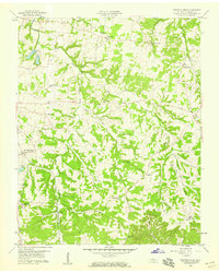
1958 Map of Fountain Head
USGS Topo · Published 1959About this map
West Fork Drakes Creek and its many tributaries, including Caney Fork and Sulphur Fork, carve a complex drainage pattern across this portion of Sumner County just south of the Kentucky line. The settlement at Fountain Head serves as a local hub along the Louisville and Nashville railroad, which dictates the placement of nearby communities like Buck Lodge. This era of the late 1950s shows a landscape still defined by its rural social centers, with Antioch Ch, Mt Moriah Ch, and Pipers Chapel anchoring small crossroads. Educational sites like Highland Academy and Parkers Chapel Sch highlight the distributed nature of the county's infrastructure before major modern consolidation. The map preserves several small, named locales such as Sengtown, Corinth, and Brackentown that illustrate the dense network of family-named settlements characteristic of Middle Tennessee's interior.
Find a feature on this map
36 named features on this map. Tap any name to fly to it.
Don’t see what you’re looking for? This feature index may not catch every label — zoom into the map to look around manually.
Map Details
Editions of this 1958 Fountain Head Map
2 editions found
Other maps of this area

1903 · Nashville
USGS Topo · 1:125,000

1928 · Adolphus
USGS Topo · 1:48,000

1931 · Adolphus
USGS Topo · 1:62,500

1942 · Gallatin
USGS Topo · 1:100,000

1951 · Franklin
USGS Topo · 1:24,000

1953 · Cottontown
USGS Topo · 1:24,000
1954 · Hickory Flat
USGS Topo · 1:24,000

1954 · Adolphus
USGS Topo · 1:24,000

1955 · Bethpage
USGS Topo · 1:24,000

1955 · Gallatin
USGS Topo · 1:24,000