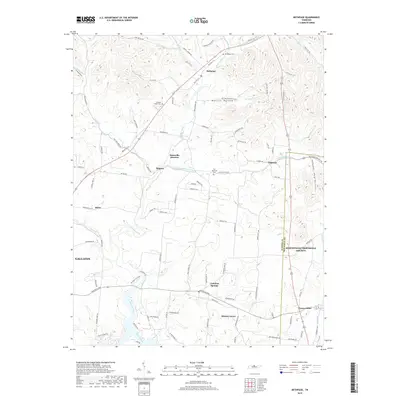
2019 Map of Bethpage
USGS Topo · Published 2019About this map
Castalian Springs and the surrounding rural landscapes of Sumner and Trousdale counties are meticulously documented in this contemporary survey. The geography is defined by the winding course of Bledsoe Creek, which feeds into the larger reservoir system near Hickory Grove. Local history and genealogy are preserved through the locations of several burial sites, including Bethpage Cem, Old Hopewell Cem, and the Durham Chapel Cem situated north of Rogana. Small crossroads and community hubs like Hartsville Junction, Chipman, and Desha punctuate the ridge-and-hollow terrain, while family-named landmarks such as Mutton Hollow and Hog Hollow reflect the area’s longstanding agricultural roots. The map traces the historical road network, specifically along Old Hwy 31E, providing a clear record of how modern transportation corridors overlay the older paths connecting these Tennessee settlements.
Find a feature on this map
105 named features on this map. Tap any name to fly to it.
Don’t see what you’re looking for? This feature index may not catch every label — zoom into the map to look around manually.
Map Details
Editions of this 2019 Bethpage Map
This is the sole edition of this map. No revisions or reprints were ever made.
Other maps of this area

1931 · Lafayette
USGS Topo · 1:62,500

1931 · Adolphus
USGS Topo · 1:62,500

1942 · Gallatin
USGS Topo · 1:100,000

1955 · Bethpage
USGS Topo · 1:24,000

1955 · Laguardo
USGS Topo · 1:24,000

1955 · Hunters Point
USGS Topo · 1:24,000

1955 · Gallatin
USGS Topo · 1:24,000

1956 · Nashville
USGS Topo · 1:250,000

1958 · Westmoreland
USGS Topo · 1:24,000
1958 · Fountain Head
USGS Topo · 1:24,000