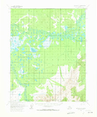
1970 Map of Bettles A-4
USGS Topo · Published 1973About this map
Kanuti River and the Kilolitna River dominate this 1970 landscape, creating an intricate network of wetlands and migratory water bodies in the Alaskan interior. The terrain is defined by a dense cluster of lakes, including the central Kanuti Lake and the nearby Old Dummy Lake, alongside smaller features like Taiholman Lake. These waterways reflect the shifting hydrology of the region, where seasonal changes and low-lying ground dictate the movement of both water and wildlife. A solitary Winter Trail provides the only evidence of overland human transit, cutting through the northern sections of the quadrangle. This route illustrates the reliance on frozen ground for transportation in a territory where traditional permanent roads are absent, favoring travel during the colder months when the surrounding swamps and river plains become navigable.
Find a feature on this map
6 named features on this map. Tap any name to fly to it.
Don’t see what you’re looking for? This feature index may not catch every label — zoom into the map to look around manually.
Map Details
Editions of this 1970 Bettles A-4 Map
This is the sole edition of this map. No revisions or reprints were ever made.
Other maps of this area

1951 · Bettles
USGS Topo · 1:250,000

1951 · Tanana
USGS Topo · 1:250,000

1956 · Bettles
USGS Topo · 1:250,000

1956 · Tanana D-4
USGS Topo · 1:63,360

1956 · Tanana D-3
USGS Topo · 1:63,360
1956 · Tanana D-5
USGS Topo · 1:63,360

1956 · Tanana
USGS Topo · 1:250,000

1960 · Tanana
USGS Topo · 1:250,000
1970 · Bettles B-4
USGS Topo · 1:63,360
1970 · Bettles A-3
USGS Topo · 1:63,360