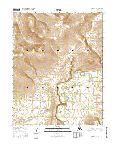
2016 Map of Bettles B-3 SE
USGS Topo · Published 2016About this map
The Kanuti River winds through the southern reaches of this landscape, its path defined by numerous oxbow lakes and wetlands that suggest a highly dynamic fluvial environment. Located in the Yukon-Koyukuk region, the terrain transitions from the low-lying river basin to elevated ridges and slopes in the northern sections, where contour lines tighten significantly. This 2016 survey, produced using data from agencies like the Alaska Dept. of Transportation and the BLM, details the township boundaries of t18n r17w and t17n r17w. The absence of roads or permanent structures underscores the wilderness character of this interior Alaskan territory, where the landscape is primarily shaped by natural water systems and elevation changes rather than human development.
Find a feature on this map
5 named features on this map. Tap any name to fly to it.
Don’t see what you’re looking for? This feature index may not catch every label — zoom into the map to look around manually.
Map Details
Editions of this 2016 Bettles B-3 SE Map
This is the sole edition of this map. No revisions or reprints were ever made.
Other maps of this area

1951 · Bettles
USGS Topo · 1:250,000

1956 · Bettles
USGS Topo · 1:250,000
1970 · Bettles A-3
USGS Topo · 1:63,360

1970 · Bettles B-2
USGS Topo · 1:63,360
1970 · Bettles B-3
USGS Topo · 1:63,360
1970 · Bettles A-2
USGS Topo · 1:63,360
2016 · Bettles B-3 SW
USGS Topo · 1:25,000
2016 · Bettles A-3 NW
USGS Topo · 1:25,000
2016 · Bettles B-3 NE
USGS Topo · 1:25,000
2016 · Bettles A-3 NE
USGS Topo · 1:25,000