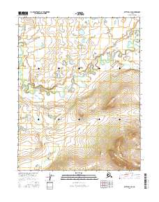
2016 Map of Bettles C-3 SE
USGS Topo · Published 2016About this map
Hulgothen Bluffs stands as a prominent topographical landmark in this interior Alaskan wilderness, overlooking the intricate winding of Fish Creek. The landscape is defined by the complex, serpentine oxbows of the creek as it meanders through the northern reaches of the quadrangle. To the northeast, the terrain transitions toward the drainage of Bonanza Creek, showcasing the primitive river systems that have shaped the Yukon-Koyukuk region. This 2016 survey captures a landscape devoid of permanent road infrastructure or settlements, instead documenting the intricate natural drainage patterns and elevation contours of the Brooks Range foothills. The precision of the public land survey system lines, including t21n r17w and t20n r16w, provides a structural grid over an otherwise untamed riverine environment.
Find a feature on this map
10 named features on this map. Tap any name to fly to it.
Don’t see what you’re looking for? This feature index may not catch every label — zoom into the map to look around manually.
Map Details
Editions of this 2016 Bettles C-3 SE Map
This is the sole edition of this map. No revisions or reprints were ever made.
Other maps of this area

1951 · Bettles
USGS Topo · 1:250,000

1956 · Bettles
USGS Topo · 1:250,000

1970 · Bettles B-2
USGS Topo · 1:63,360
1970 · Bettles B-3
USGS Topo · 1:63,360

1970 · Bettles C-2
USGS Topo · 1:63,360
1970 · Bettles C-3
USGS Topo · 1:63,360
2016 · Bettles C-3 NW
USGS Topo · 1:25,000
2016 · Bettles C-3 NE
USGS Topo · 1:25,000
2016 · Bettles B-3 NE
USGS Topo · 1:25,000
2016 · Bettles B-3 NW
USGS Topo · 1:25,000