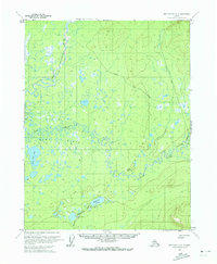
1970 Map of Bettles C-3
USGS Topo · Published 1973About this map
South Fork Koyukuk River winds through this subarctic landscape in the early 1970s, defining a region characterized by complex hydrologic networks. The southern half of the map is dominated by the Kanuti Flats, an expansive wetland system where the Fish Creek and Chatatna Creek meander through countless unnamed ponds and significant water bodies like Fish Creek Lake and Kaldolyeit Lake. The topography shifts at Hulgothen Bluffs, where the ground rises above the saturated lowlands of the Kanuti Chatanika Lake area.
Find a feature on this map
10 named features on this map. Tap any name to fly to it.
Don’t see what you’re looking for? This feature index may not catch every label — zoom into the map to look around manually.
Map Details
Editions of this 1970 Bettles C-3 Map
This is the sole edition of this map. No revisions or reprints were ever made.
Other maps of this area

1951 · Bettles
USGS Topo · 1:250,000

1956 · Bettles
USGS Topo · 1:250,000
1970 · Bettles B-4
USGS Topo · 1:63,360

1970 · Bettles D-4
USGS Topo · 1:63,360

1970 · Bettles B-2
USGS Topo · 1:63,360

1970 · Bettles C-4
USGS Topo · 1:63,360
1970 · Bettles B-3
USGS Topo · 1:63,360

1970 · Bettles D-3
USGS Topo · 1:63,360

1970 · Bettles C-2
USGS Topo · 1:63,360

1970 · Bettles D-2
USGS Topo · 1:63,360