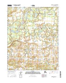
2016 Map of Bettles C-4 SW
USGS Topo · Published 2016About this map
The Koyukuk River and the South Fork Koyukuk River dominate this interior Alaskan landscape, where the shifting hydrology of the subarctic takes center stage. This portion of the Yukon-Koyukuk region is characterized by an intricate network of oxbow lakes, abandoned river channels, and meandering tributaries that illustrate the constant movement of the water across the basin. The survey details the convergence of these major water systems within several townships, including t21n r20w and t20n r21w, showing a wilderness shaped entirely by natural forces. While void of permanent settlements or infrastructure, the map serves as a primary record for those studying the geomorphology of the Alaskan interior or the traditional navigation routes used along these significant northern waterways during the early 21st century.
Find a feature on this map
8 named features on this map. Tap any name to fly to it.
Don’t see what you’re looking for? This feature index may not catch every label — zoom into the map to look around manually.
Map Details
Editions of this 2016 Bettles C-4 SW Map
This is the sole edition of this map. No revisions or reprints were ever made.
Other maps of this area

1951 · Bettles
USGS Topo · 1:250,000

1956 · Bettles
USGS Topo · 1:250,000
1970 · Bettles B-4
USGS Topo · 1:63,360

1970 · Bettles C-4
USGS Topo · 1:63,360
1970 · Bettles B-5
USGS Topo · 1:63,360
1970 · Bettles C-5
USGS Topo · 1:63,360
2016 · Bettles B-4 NE
USGS Topo · 1:25,000
2016 · Bettles B-5 NE
USGS Topo · 1:25,000
2016 · Bettles C-4 NE
USGS Topo · 1:25,000
2016 · Bettles B-4 NW
USGS Topo · 1:25,000