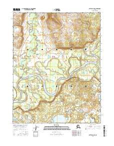
2016 Map of Bettles C-5 SE
USGS Topo · Published 2016About this map
The Koyukuk River meanders across this northern landscape, carving a wide alluvial basin characterized by oxbow lakes and complex hydraulic patterns. This remote section of the Yukon-Koyukuk region highlights the dynamic nature of Arctic waterways, where the river's main channel is fed by tributaries like Henshaw Creek. The terrain is largely defined by low-lying wetlands and seasonal floodplains, punctuated by standing bodies of water such as Mingkoket Lake in the southern portion of the quadrangle. Surveyed for the U.S. Geological Survey, the map provides a precise record of the hydrologic landscape and township boundaries, including t20n r21w and t21n r21w, showing a wilderness shaped by water rather than permanent settlement.
Find a feature on this map
9 named features on this map. Tap any name to fly to it.
Don’t see what you’re looking for? This feature index may not catch every label — zoom into the map to look around manually.
Map Details
Editions of this 2016 Bettles C-5 SE Map
This is the sole edition of this map. No revisions or reprints were ever made.
Other maps of this area

1951 · Bettles
USGS Topo · 1:250,000

1956 · Bettles
USGS Topo · 1:250,000
1970 · Bettles B-4
USGS Topo · 1:63,360

1970 · Bettles C-4
USGS Topo · 1:63,360
1970 · Bettles B-5
USGS Topo · 1:63,360
1970 · Bettles C-5
USGS Topo · 1:63,360
2016 · Bettles B-5 NW
USGS Topo · 1:25,000
2016 · Bettles B-5 NE
USGS Topo · 1:25,000
2016 · Bettles B-4 NW
USGS Topo · 1:25,000
2016 · Bettles C-4 NW
USGS Topo · 1:25,000