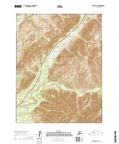
2017 Map of Bettles D-1 NW
USGS Topo · Published 2017About this map
The Alaska Pipeline and the Dalton Highway serve as the primary human corridor through this part of the Yukon-Koyukuk Census Area. These critical infrastructure lines run parallel through the center of the sheet, traversing a landscape defined by the drainage systems of the South Fork Koyukuk River and the Jim River. This 2017 survey illustrates the intersection of modern industrial logistics with the natural geography of the interior, where the pipeline must navigate the topographical shifts between Grayling Lake and various tributary streams. The presence of Grayling Cr and Bear Cr suggests a region defined by seasonal water flow and subarctic terrain, maintained primarily for transport and resource transit rather than permanent settlement.
Find a feature on this map
11 named features on this map. Tap any name to fly to it.
Don’t see what you’re looking for? This feature index may not catch every label — zoom into the map to look around manually.
Map Details
Editions of this 2017 Bettles D-1 NW Map
This is the sole edition of this map. No revisions or reprints were ever made.
Other maps of this area

1951 · Bettles
USGS Topo · 1:250,000

1951 · Wiseman
USGS Topo · 1:250,000

1956 · Bettles
USGS Topo · 1:250,000

1956 · Wiseman
USGS Topo · 1:250,000

1964 · Wiseman
USGS Topo · 1:250,000

1970 · Wiseman A-1
USGS Topo · 1:63,360
1970 · Bettles D-1
USGS Topo · 1:63,360

1970 · Wiseman A-2
USGS Topo · 1:63,360

1970 · Bettles D-2
USGS Topo · 1:63,360
2017 · Wiseman A-1 SW
USGS Topo · 1:25,000