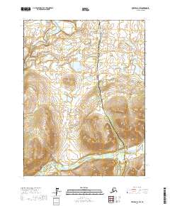
2017 Map of Wiseman A-1 SW
USGS Topo · Published 2017About this map
The Alaska Pipeline and the adjacent Dalton Highway dominate the north-south axis of this sub-Arctic landscape, cutting a modern industrial corridor through the wilderness. These engineering feats parallel the natural drainage of the Middle Fork Koyukuk River and its various tributaries. The map shows the intricate wetland patterns and shifting hydrology of the region, evidenced by features such as Chapman Island and the meandering Chapman Cr. In the northern portion of the quadrangle, the Windy Arm feeds into the larger river system, while the southern reaches are defined by the presence of the South Fork Koyukuk River. This document captures the stark contrast between the remote, uninhabited terrain of the Yukon-Koyukuk region and the critical energy infrastructure that traverses it.
Find a feature on this map
13 named features on this map. Tap any name to fly to it.
Don’t see what you’re looking for? This feature index may not catch every label — zoom into the map to look around manually.
Map Details
Editions of this 2017 Wiseman A-1 SW Map
This is the sole edition of this map. No revisions or reprints were ever made.
Other maps of this area

1951 · Bettles
USGS Topo · 1:250,000

1951 · Wiseman
USGS Topo · 1:250,000

1956 · Bettles
USGS Topo · 1:250,000

1956 · Wiseman
USGS Topo · 1:250,000

1964 · Wiseman
USGS Topo · 1:250,000

1970 · Wiseman A-1
USGS Topo · 1:63,360
1970 · Bettles D-1
USGS Topo · 1:63,360

1970 · Wiseman A-2
USGS Topo · 1:63,360

1970 · Bettles D-2
USGS Topo · 1:63,360
2017 · Wiseman A-2 NE
USGS Topo · 1:25,000