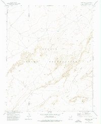
1972 Map of Betty Well
USGS Topo · Published 1976About this map
Betty Well sits at the heart of this high-desert landscape within the Navajo Indian Reservation, an area defined by wide drainage systems and seasonal watercourses. The 1972 survey captures the sparse infrastructure of the region, where the Navajo Co Apache Co line runs north-south across open terrain. Water management and livestock movement are the primary markers of human activity here, evidenced by the presence of a Corral and the wide, winding paths of the Pueblo Colorado Wash and Sabito Wash. This map is particularly useful for understanding the historic land use of the reservation during the early 1970s, showing the specific locations of isolated water sources and ranching structures that served as essential landmarks in the vast expanse between settlements.
Find a feature on this map
6 named features on this map. Tap any name to fly to it.
Don’t see what you’re looking for? This feature index may not catch every label — zoom into the map to look around manually.
Map Details
Editions of this 1972 Betty Well Map
This is the sole edition of this map. No revisions or reprints were ever made.
Other maps of this area

1886 · Fort Defiance
USGS Topo · 1:250,000

1892 · Fort Defiance
USGS Topo · 1:250,000

1954 · Gallup
USGS Topo · 1:250,000

1958 · Gallup
USGS Topo · 1:250,000

1959 · Gallup
USGS Topo · 1:250,000

1962 · Gallup
USGS Topo · 1:250,000

1967 · Gallup
USGS Topo · 1:250,000
1972 · Pilot Rock
USGS Topo · 1:24,000
1972 · Tanner Springs
USGS Topo · 1:24,000
1972 · North Mill Well
USGS Topo · 1:24,000