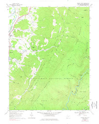
1969 Map of Beverly East
USGS Topo · Published 1977About this map
Tygart Valley River and the high ridges of Cheat Mountain define the topography of this Randolph County survey from the late 1960s. The western edge follows the river valley through Hazelwood and the borough of Beverly, where the Western Maryland rail line parallels the water. Moving east, the terrain rises sharply into the Monongahela National Forest, a landscape of deeply cut runs and high summits like Imboden Knob and Childers Knob.
Find a feature on this map
62 named features on this map. Tap any name to fly to it.
Don’t see what you’re looking for? This feature index may not catch every label — zoom into the map to look around manually.
Map Details
Editions of this 1969 Beverly East Map
3 editions found
Other maps of this area

1889 · Beverly
USGS Topo · 1:125,000

1892 · Beverly
USGS Topo · 1:125,000

1909 · Elkins
USGS Topo · 1:62,500

1922 · Horton
USGS Topo · 1:48,000

1922 · Spruce Knob
USGS Topo · 1:48,000

1922 · Durbin
USGS Topo · 1:48,000

1924 · Durbin
USGS Topo · 1:62,500

1924 · Horton
USGS Topo · 1:62,500

1924 · Spruce Knob
USGS Topo · 1:62,500

1949 · Charlottesville
USGS Topo · 1:250,000