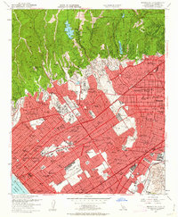
1950 Map of Beverly Hills
USGS Topo · Published 1963About this map
The Santa Monica Mountains drop sharply into the burgeoning postwar sprawl of West Los Angeles, revealing a landscape defined by rapid suburbanization and the global influence of the entertainment industry. Massive studio lots, including Twentieth Century Fox Studios, MGM Studios, and Selznick Studios, occupy significant acreage alongside the prestigious University of California at Los Angeles campus. The built environment is characterized by an extensive grid of boulevards like Wilshire Blvd and Sunset Blvd, while the Pacific Electric railway still carves its path through the region.
Find a feature on this map
129 named features on this map. Tap any name to fly to it.
Don’t see what you’re looking for? This feature index may not catch every label — zoom into the map to look around manually.
Map Details
Editions of this 1950 Beverly Hills Map
4 editions found
Other maps of this area

1894 · Los Angeles
USGS Topo · 1:62,500

1896 · Redondo
USGS Topo · 1:62,500

1896 · Santa Monica
USGS Topo · 1:62,500

1898 · Santa Monica
USGS Topo · 1:62,500

1900 · Los Angeles
USGS Topo · 1:62,500

1901 · Southern California Sheet No. 1
USGS Topo · 1:250,000

1902 · Santa Monica
USGS Topo · 1:62,500

1903 · Calabasas
USGS Topo · 1:62,500

1903 · Camulos
USGS Topo · 1:125,000

1904 · Southern California Sheet No. 1
USGS Topo · 1:250,000