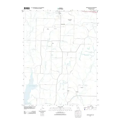
2012 Map of Bevier South
USGS Topo · Published 2012About this map
The Middle Fork and East Fork Little Chariton River define the hydrological character of this Macon County landscape, with the southern portion dominated by the reach of the Thomas Hill Reservoir. This area has long been shaped by industrial activity, as evidenced by the namesake of the Central Coal and Coke Corporation Lake Dam and the presence of small, discrete settlements like Number Eight, Northwestern, and Keota. These locations, alongside Binkley and Ardmore, reflect a historic pattern of proximity to natural resources and transportation corridors. The map records a complex network of small local roads, such as Heritage Rd and Intrepid Rd, which connect these established communities to the larger hub of Bevier at the northern edge. The presence of several dams, including Keota Lake Dam, underscores the managed water systems critical to both industrial and agricultural development in this part of Missouri.
Find a feature on this map
58 named features on this map. Tap any name to fly to it.
Don’t see what you’re looking for? This feature index may not catch every label — zoom into the map to look around manually.
Map Details
Editions of this 2012 Bevier South Map
This is the sole edition of this map. No revisions or reprints were ever made.
Other maps of this area

1908 · Atlanta
USGS Topo · 1:62,500

1908 · Macon
USGS Topo · 1:62,500

1910 · Macon
USGS Topo · 1:62,500

1937 · Elmer
USGS Topo · 1:48,000

1942 · Elmer
USGS Topo · 1:62,500

1953 · Moberly
USGS Topo · 1:250,000

1953 · Bevier South
USGS Topo · 1:24,000

1953 · College Mound
USGS Topo · 1:24,000

1953 · Prairie Hill
USGS Topo · 1:24,000

1953 · Lagonda
USGS Topo · 1:24,000