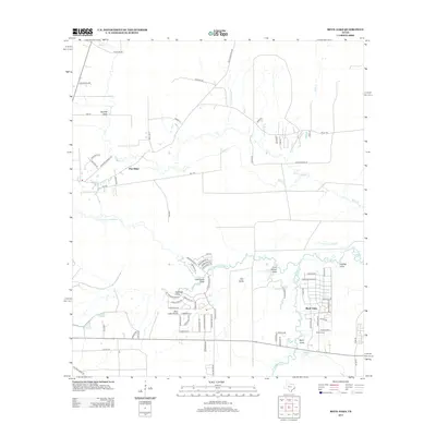
2013 Map of Bevil Oaks
USGS Topo · Published 2013About this map
Pine Island Bayou and its winding tributaries define the landscape of this Southeast Texas region in Hardin and Jefferson Counties. The residential street patterns of Bevil Oaks and the neighboring Bevel Acres are clearly visible, illustrating the suburban growth along the bayou's edge. The terrain is characterized by numerous drainage features, including Coon Marsh Gully, Byrd Gully, and Clemmons Gully, which crisscross the low-lying coastal plain. These natural waterways dictate the layout of local roads such as Pelt RD and FM 421 RD. Farther west, the settlement of Pine Ridge sits near the headwaters of several creeks, including Black Cr. The map captures a transition between residential development and the natural swampy environment, seen in features like Reeder Slough and Fish Camp Slough, which speak to the area's hydrology and local recreation sites such as Fertitta Lake.
Find a feature on this map
83 named features on this map. Tap any name to fly to it.
Don’t see what you’re looking for? This feature index may not catch every label — zoom into the map to look around manually.
Map Details
Editions of this 2013 Bevil Oaks Map
This is the sole edition of this map. No revisions or reprints were ever made.
Other maps of this area

1932 · Beaumont
USGS Topo · 1:62,500

1954 · Beaumont
USGS Topo · 1:250,000

1955 · Silsbee
USGS Topo · 1:62,500

1955 · Kountze
USGS Topo · 1:62,500

1955 · Sour Lake
USGS Topo · 1:62,500

1957 · Beaumont
USGS Topo · 1:250,000
1960 · Beaumont West
USGS Topo · 1:24,000
1960 · Voth
USGS Topo · 1:24,000

1984 · Beaumont
USGS Topo · 1:250,000
1984 · Nome
USGS Topo · 1:24,000