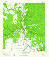
1960 Map of Voth
USGS Topo · Published 1962About this map
Pine Island Bayou meanders along the boundary of Hardin and Jefferson counties, serving as the central geographic feature of this 1960 landscape. The area shows a transition from the developing northern outskirts of Beaumont to the active industrial and rural spaces to the north. Industry and infrastructure are prominent, evidenced by the Ariola Oil Field and the intricate rail network of the Southern Pacific and Gulf Colorado and Santa Fe railroads. Local life is anchored by small communities such as Voth, Loeb, and Rosedale, each supported by neighborhood institutions like the Voth-Rosedale Sch and Mt Sinai Ch. The terrain north of the bayou is defined by complex water features, including Sandy Slough and Village Creek, reflecting the low-lying coastal plain environment. Numerous family and local road names like Walker Road and Toliver Road provide specific points of interest for genealogical research.
Find a feature on this map
60 named features on this map. Tap any name to fly to it.
Don’t see what you’re looking for? This feature index may not catch every label — zoom into the map to look around manually.
Map Details
Editions of this 1960 Voth Map
3 editions found
Other maps of this area

1926 · Lakeview
USGS Topo · 1:24,000

1926 · Vidor
USGS Topo · 1:24,000

1932 · Beaumont
USGS Topo · 1:62,500

1943 · Beaumont East
USGS Topo · 1:24,000

1954 · Beaumont
USGS Topo · 1:250,000

1955 · Silsbee
USGS Topo · 1:62,500

1955 · Kountze
USGS Topo · 1:62,500

1955 · Sour Lake
USGS Topo · 1:62,500

1957 · Beaumont
USGS Topo · 1:250,000
1960 · Beaumont West
USGS Topo · 1:24,000