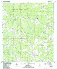
1988 Map of Bewelcome
USGS Topo · Published 1988About this map
The Homochitto National Forest occupies the northern half of this rural Amite County landscape, where the terrain is defined by the headwaters of numerous small waterways like Brushy Creek, Clear Prong, and Days Creek. The settlement of Bewelcome serves as a central point, surrounded by a network of small country churches including Woodlawn Ch and Star Hill Ch. This 1980s data highlights a community rooted in small rural outposts like Compromise, Enterprise, and White Cap, many of which grew around family-named landmarks such as Graves Chapel and Talbert Cem. The presence of several gravel pits and the Pine Hills Country Club suggests a mix of local industry and recreational development. Farther south, the geography transitions into a denser web of drainage branches, including Meetinghouse Branch and Waggoner Creek, punctuated by older sites like Plymouth Ch and the Waggoner Cemetery.
Find a feature on this map
40 named features on this map. Tap any name to fly to it.
Don’t see what you’re looking for? This feature index may not catch every label — zoom into the map to look around manually.
Map Details
Editions of this 1988 Bewelcome Map
This is the sole edition of this map. No revisions or reprints were ever made.
Other maps of this area

1953 · Natchez
USGS Topo · 1:250,000

1956 · Natchez
USGS Topo · 1:250,000

1959 · Natchez
USGS Topo · 1:250,000

1961 · Liberty
USGS Topo · 1:62,500

1961 · Crosby
USGS Topo · 1:62,500

1961 · Gloster
USGS Topo · 1:62,500

1962 · Bude
USGS Topo · 1:62,500

1984 · McComb
USGS Topo · 1:100,000

1984 · Woodville
USGS Topo · 1:100,000
1988 · Homochitto
USGS Topo · 1:24,000