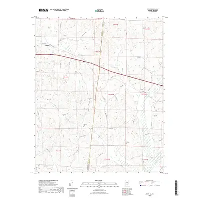
2020 Map of Bexar
USGS Topo · Published 2020About this map
The Mississippi-Alabama state line divides this 2020 study, where the communities of Tremont and Bexar serve as local anchors. This rural borderland is characterized by a high density of family and community burial grounds, including the Robinson Cem, Stevens Cem, and Concord Cem, reflecting generations of settlement in the hills above Hurricane Cr. The landscape is defined by its watercourses, such as Johns Cr and Splunge Cr, which dictate the winding paths of rural connectors like Bankhead Rd NE and State Line Rd SE. The presence of the Bexar Gin Rd points to the agricultural roots of the area, while the modern corridor of Interstate 22 now cuts through the traditional terrain once navigated solely by routes like McFadden Dr and Harbor Rd.
Find a feature on this map
84 named features on this map. Tap any name to fly to it.
Don’t see what you’re looking for? This feature index may not catch every label — zoom into the map to look around manually.
Map Details
Editions of this 2020 Bexar Map
This is the sole edition of this map. No revisions or reprints were ever made.
Other maps of this area

1936 · Vina
USGS Topo · 1:24,000

1950 · Vina
USGS Topo · 1:24,000

1951 · Vina
USGS Topo · 1:24,000

1956 · Tupelo
USGS Topo · 1:250,000

1958 · Tupelo
USGS Topo · 1:250,000

1965 · Fulton SE
USGS Topo · 1:24,000

1966 · Turon
USGS Topo · 1:24,000

1966 · Tremont
USGS Topo · 1:24,000
1967 · Weston
USGS Topo · 1:24,000
1967 · Henson Springs
USGS Topo · 1:24,000