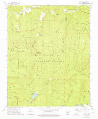
1973 Map of Bidville
USGS Topo · Published 1976About this map
White Rock Mountain dominates the center of this Ozark landscape, serving as a hub for the Ozark National Forest during the early 1970s. The map reveals a deeply etched topography of ridges and hollows, where small settlements like Bidville and Summit are tucked away near family burial grounds such as Bidville Cem and Phillips Cem. In the south, the Mulberry River winds past Milton Ford, a crossing point that highlights the historical importance of river access before modern bridge infrastructure was pervasive.
Find a feature on this map
75 named features on this map. Tap any name to fly to it.
Don’t see what you’re looking for? This feature index may not catch every label — zoom into the map to look around manually.
Map Details
Editions of this 1973 Bidville Map
3 editions found
Other maps of this area

1879 · Cravens
USGS Topo · 1:62,500

1887 · Watalula
USGS Topo · 1:62,500

1898 · Winslow #4
USGS Topo · 1:62,500

1898 · Winslow
USGS Topo · 1:125,000

1901 · Winslow
USGS Topo · 1:125,000

1939 · Watalula
USGS Topo · 1:62,500

1943 · St. Paul
USGS Topo · 1:62,500

1946 · St. Paul
USGS Topo · 1:62,500

1946 · Fort Smith
USGS Topo · 1:250,000

1956 · Russellville
USGS Topo · 1:250,000