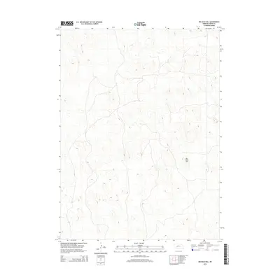
2014 Map of Big Bald Hill
USGS Topo · Published 2014About this map
The rolling sandhill terrain of northern Keith County is the defining characteristic of this landscape. The topographic survey focuses on the intricate contour patterns of the western Nebraska plains, where seasonal drainage basins and varied elevations dominate the map. The namesake Big Bald Hill stands as a prominent high point in the southeastern quadrant, serving as a primary navigational landmark for the surrounding ranchlands. The road network shown reflects the sparse, rural nature of the region, consisting of localized connectors and paths that follow the natural folds of the earth between elevations. This 2014 data provides a clear record of the area's physical geography before any modern shifts in land use or infrastructure development.
Find a feature on this map
1 named feature on this map. Tap any name to fly to it.
Don’t see what you’re looking for? This feature index may not catch every label — zoom into the map to look around manually.
Map Details
Editions of this 2014 Big Bald Hill Map
This is the sole edition of this map. No revisions or reprints were ever made.
Other maps of this area

1897 · Ogallala
USGS Topo · 1:125,000

1898 · Paxton
USGS Topo · 1:125,000

1900 · Ogallala
USGS Topo · 1:125,000

1901 · Paxton
USGS Topo · 1:125,000

1954 · North Platte
USGS Topo · 1:250,000

1956 · North Platte
USGS Topo · 1:250,000

1957 · North Platte
USGS Topo · 1:250,000

1967 · North Platte
USGS Topo · 1:250,000
1971 · Spotted Horse Valley
USGS Topo · 1:24,000
1971 · Glinn Ranch
USGS Topo · 1:24,000