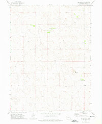
1972 Map of Big Bald Hill
USGS Topo · Published 1975About this map
Big Bald Hill rises as the central topographic landmark in this section of the Nebraska Sandhills, a landscape defined by its distinctive dune formations and isolated ranching outposts. This 1970s survey captures a sparsely settled portion of Keith County where human presence is marked primarily by large private holdings such as Barnt Ranch in the north and Rudd Ranch to the southeast. The map details a complex network of fence lines and windmills, reflecting the infrastructure required for cattle ranching in an arid environment. The terrain is characterized by the intricate contour patterns of the hills, providing a precise record of the natural landforms before modern land use might alter the subtle drainage and blowouts characteristic of this region.
Find a feature on this map
6 named features on this map. Tap any name to fly to it.
Don’t see what you’re looking for? This feature index may not catch every label — zoom into the map to look around manually.
Map Details
Editions of this 1972 Big Bald Hill Map
This is the sole edition of this map. No revisions or reprints were ever made.
Other maps of this area

1897 · Ogallala
USGS Topo · 1:125,000

1898 · Paxton
USGS Topo · 1:125,000

1900 · Ogallala
USGS Topo · 1:125,000

1901 · Paxton
USGS Topo · 1:125,000

1954 · North Platte
USGS Topo · 1:250,000

1956 · North Platte
USGS Topo · 1:250,000

1957 · North Platte
USGS Topo · 1:250,000

1967 · North Platte
USGS Topo · 1:250,000
1971 · Spotted Horse Valley
USGS Topo · 1:24,000
1971 · Glinn Ranch
USGS Topo · 1:24,000