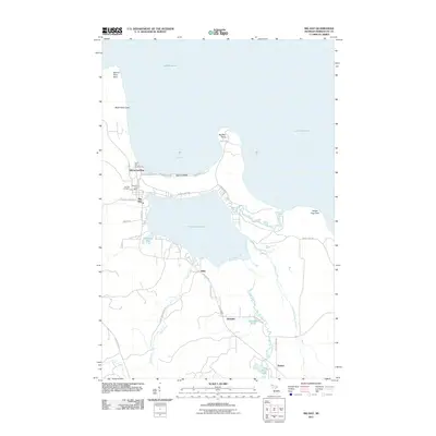
2011 Map of Big Bay
USGS Topo · Published 2011About this map
Big Bay sits at the nexus of Lake Superior's shoreline and the inland waters of Lake Independence, serving as the primary settlement in this northern Marquette County landscape. The community structure is anchored by the Big Bay Post Office and the nearby Big Bay Cemetery, while the northern coast is defined by prominent landmarks such as Big Bay Point and Squaw Beach. Moving inland, the terrain follows a network of timber and access routes like the Alder Creek Truck Trl, which leads toward Alder Falls. Smaller residential clusters and landings, including Burns Landing, Alder, and Homeier, are scattered along the county roads, reflecting a pattern of settlement tied to the lakefront and the surrounding forests. The map also captures the specialized infrastructure of the Bay Cliff Health Camp and the confluence of the Iron River and Yellow Dog River as they meet the Great Lake at Big Bay.
Find a feature on this map
42 named features on this map. Tap any name to fly to it.
Don’t see what you’re looking for? This feature index may not catch every label — zoom into the map to look around manually.
Map Details
Editions of this 2011 Big Bay Map
This is the sole edition of this map. No revisions or reprints were ever made.
Other maps of this area

1954 · Negaunee
USGS Topo · 1:62,500

1954 · Huron Mountain
USGS Topo · 1:62,500

1954 · Big Bay
USGS Topo · 1:62,500

1955 · Champion
USGS Topo · 1:62,500

1958 · Marquette
USGS Topo · 1:250,000

1960 · Marquette
USGS Topo · 1:250,000

1961 · Marquette
USGS Topo · 1:250,000

1968 · Marquette
USGS Topo · 1:250,000
1984 · Ives Hill
USGS Topo · 1:24,000
1985 · Huron Mountain
USGS Topo · 1:24,000