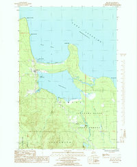
1985 Map of Big Bay
USGS Topo · Published 1985About this map
The coastal village of Big Bay sits at the junction of Lake Independence and the southwestern sweep of its namesake bay on Lake Superior. This 1985 provisional study captures a landscape defined by industrial history and Lake Superior's shoreline, where the Escanaba River State Forest blankets the southern terrain. A notable trace of former timber and freight operations is visible in the Old RR Grade winding through the woods south of the lake, linking the community toward Homeier and Antlers.
Find a feature on this map
29 named features on this map. Tap any name to fly to it.
Don’t see what you’re looking for? This feature index may not catch every label — zoom into the map to look around manually.
Map Details
Editions of this 1985 Big Bay Map
This is the sole edition of this map. No revisions or reprints were ever made.
Other maps of this area

1954 · Negaunee
USGS Topo · 1:62,500

1954 · Huron Mountain
USGS Topo · 1:62,500

1954 · Big Bay
USGS Topo · 1:62,500

1955 · Champion
USGS Topo · 1:62,500

1958 · Marquette
USGS Topo · 1:250,000

1960 · Marquette
USGS Topo · 1:250,000

1961 · Marquette
USGS Topo · 1:250,000

1968 · Marquette
USGS Topo · 1:250,000
1984 · Ives Hill
USGS Topo · 1:24,000
1985 · Huron Mountain
USGS Topo · 1:24,000