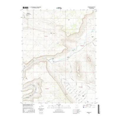
2017 Map of Big Bend
USGS Topo · Published 2017About this map
Colorado River water levels and the iconic Delicate Arch define the northwestern corner of this study, where the boundary of Arches National Park meets the high desert plateaus. The landscape is characterized by deep erosion and dramatic elevation changes, evidenced by the towering Parriott Mesa and the sweeping Porcupine Rim that overlook the valley floor. In the southern portion of the sheet, the residential development of Castle Valley is clearly mapped, showing a grid of local roads like Castle Valley Dr and Creekside Ln. This map provides significant detail for local historians, documenting both the Castle Valley Cem and Red Cliffs Cem. The river corridor itself is marked by numerous hazards for navigators, including White Rapids and Professor Creek Rapids, tracing the vital water route through Professor Valley and Ida Gulch.
Find a feature on this map
57 named features on this map. Tap any name to fly to it.
Don’t see what you’re looking for? This feature index may not catch every label — zoom into the map to look around manually.
Map Details
Editions of this 2017 Big Bend Map
This is the sole edition of this map. No revisions or reprints were ever made.
Other maps of this area

1885 · La Sal
USGS Topo · 1:250,000

1954 · Mt. Waas 3 NE
USGS Topo · 1:24,000

1954 · Mt. Waas 3 SE
USGS Topo · 1:24,000

1954 · Mt. Waas 3 NW
USGS Topo · 1:24,000

1954 · Mt. Waas 3 SW
USGS Topo · 1:24,000

1954 · Castle Valley
USGS Topo · 1:62,500

1955 · Mt. Waas 2 SE
USGS Topo · 1:24,000

1956 · Moab
USGS Topo · 1:250,000

1958 · Thompson
USGS Topo · 1:62,500

1958 · Cisco
USGS Topo · 1:62,500