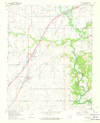
1971 Map of Big Cabin
USGS Topo · Published 1973About this map
The settlement of Big Cabin sits at a critical transportation junction in the early 1970s, where the Missouri-Kansas-Texas railroad intersects with the modern sweep of the Will Rogers Toll Road. This corner of Craig County exhibits a transition from traditional rural life to post-war infrastructure, marked by the massive Big Cabin Interchange and its associated tollgate. Rural history remains visible through features like Ironside Sch and family-named sites such as Landrum Cem.
Find a feature on this map
28 named features on this map. Tap any name to fly to it.
Don’t see what you’re looking for? This feature index may not catch every label — zoom into the map to look around manually.
Map Details
Editions of this 1971 Big Cabin Map
This is the sole edition of this map. No revisions or reprints were ever made.
Other maps of this area

1896 · Pryor
USGS Topo · 1:125,000

1901 · Vinita
USGS Topo · 1:125,000

1901 · Pryor
USGS Topo · 1:125,000

1913 · Vinita
USGS Topo · 1:125,000

1954 · Tulsa
USGS Topo · 1:250,000

1958 · Tulsa
USGS Topo · 1:250,000

1963 · Tulsa
USGS Topo · 1:250,000

1969 · Adair
USGS Topo · 1:24,000

1970 · White Oak
USGS Topo · 1:24,000
1971 · Strang
USGS Topo · 1:24,000