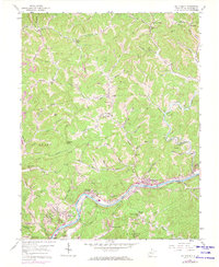
1958 Map of Big Chimney
USGS Topo · Published 1973About this map
The Elk River winds through this central West Virginia landscape, anchoring a valley of small settlements and transportation corridors just north of the state capital. By the late 1950s, the community of Big Chimney (Clyde) and neighboring Elk Hills (Mink Shoals) served as local hubs, connected by the Baltimore and Ohio railroad line tracing the river's edge. The uplands are defined by a dense network of hollows and forks, such as Aarons Fork and Coopers Creek, where family-named landmarks like Griffith Chapel and the McKinley Sch suggest a long-established rural community structure. To the south, the development of the Kanawha Airport and Coonskin Park signals the encroaching suburban growth of the mid-20th century. Traditional resource extraction remains evident through several labeled mines and strip mines scattered across the ridges, while numerous pipelines cut across the topography, illustrating the region's industrial role in energy transit.
Find a feature on this map
74 named features on this map. Tap any name to fly to it.
Don’t see what you’re looking for? This feature index may not catch every label — zoom into the map to look around manually.
Map Details
Editions of this 1958 Big Chimney Map
4 editions found
Other maps of this area

1897 · Kanawha Falls
USGS Topo · 1:125,000

1899 · Charleston
USGS Topo · 1:125,000

1900 · Kanawha Falls
USGS Topo · 1:125,000

1901 · Kanawha Falls
USGS Topo · 1:125,000

1906 · Kenna
USGS Topo · 1:62,500

1906 · Walton
USGS Topo · 1:62,500

1907 · Kenna
USGS Topo · 1:62,500

1907 · Walton
USGS Topo · 1:62,500

1907 · Clendenin
USGS Topo · 1:62,500

1909 · Charleston
USGS Topo · 1:62,500