
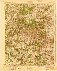
1932 Map of Big Clifty
USGS Topo · Published 1932About this map
The Illinois Central Railroad cuts across this Kentucky landscape, linking the rail-town of Big Clifty with industrial and agricultural hubs during the late 1920s. Along this corridor, the local economy is evidenced by a prominent Asphalt Mine near the railroad tracks and a Quarry situated closer to Stephensburg. The terrain is characterized by winding watercourses like the Nolin River and Meeting Creek, where family-named landmarks such as Bland Knobs and Buzzard Cliff define the horizon.
Find a feature on this map
97 named features on this map. Tap any name to fly to it.
Don’t see what you’re looking for? This feature index may not catch every label — zoom into the map to look around manually.
Map Details
Editions of this 1932 Big Clifty Map
5 editions found
Other maps of this area

1922 · Leitchfield
USGS Topo · 1:48,000

1925 · Cub Run
USGS Topo · 1:62,500

1925 · Leitchfield
USGS Topo · 1:62,500

1928 · Hardinsburg
USGS Topo · 1:48,000

1931 · Hardinsburg
USGS Topo · 1:62,500

1934 · Munfordville
USGS Topo · 1:48,000

1935 · Elizabethtown
USGS Topo · 1:48,000

1936 · Vine Grove
USGS Topo · 1:62,500

1937 · Munfordville
USGS Topo · 1:62,500

1938 · Elizabethtown
USGS Topo · 1:62,500