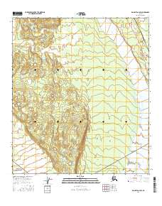
2016 Map of Big Delta A-4 SW
USGS Topo · Published 2016About this map
The Delta River corridor serves as the primary geographic focus of this 2016 survey, where the braided river valley meets the engineered infrastructure of the Alaskan interior. This map documents a critical transportation and energy hub, featuring the intersection of the Richardson Highway and the Alaska Pipeline. These two arteries parallel the river's path, cutting through a landscape of extensive wetlands and varying elevations. Local transit is managed through a network of secondary routes including Larry Spengler Road and Tanana Loop Road, while smaller residential or access roads like Sipes Road and Rebecca Lane indicate pockets of settlement or operations near the highway corridor. The map provides a precise look at the land survey divisions, spanning Townships 9 and 10 South, Ranges 9 and 10 East, illustrating how modern infrastructure is superimposed upon the expansive natural terrain.
Find a feature on this map
11 named features on this map. Tap any name to fly to it.
Don’t see what you’re looking for? This feature index may not catch every label — zoom into the map to look around manually.
Map Details
Editions of this 2016 Big Delta A-4 SW Map
This is the sole edition of this map. No revisions or reprints were ever made.
Other maps of this area

1950 · Mount Hayes
USGS Topo · 1:250,000

1950 · Big Delta
USGS Topo · 1:250,000

1950 · Big Delta A-5
USGS Topo · 1:63,360

1950 · Mount Hayes D-4
USGS Topo · 1:63,360

1950 · Big Delta A-4
USGS Topo · 1:63,360

1950 · Mount Hayes D-5
USGS Topo · 1:63,360

1951 · Big Delta
USGS Topo · 1:250,000

1951 · Mount Hayes
USGS Topo · 1:250,000

1952 · Mount Hayes D-5
USGS Topo · 1:63,360

1952 · Big Delta A-5
USGS Topo · 1:63,360