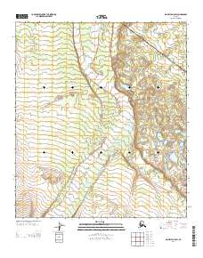
2013 Map of Big Delta A-5 SW
USGS Topo · Published 2013About this map
Delta Creek dominates this interior Alaskan landscape, its braided channels and wide gravel beds cutting a distinctive path through the terrain as documented in 2013. The waterway’s complex shifting patterns are set against a backdrop of increasing elevation, where subtle contour lines reveal the rising topography of the Southeast Fairbanks region. East of the main creek bed lies Summer Lake, a small body of water situated where the drainage basin meets more defined slopes. This survey provides a precise view of the hydrological and topographic character of the Alaskan wilderness before the influence of significant modern infrastructure, focusing on the natural interplay between the expansive creek system and the surrounding uplands.
Find a feature on this map
5 named features on this map. Tap any name to fly to it.
Don’t see what you’re looking for? This feature index may not catch every label — zoom into the map to look around manually.
Map Details
Editions of this 2013 Big Delta A-5 SW Map
This is the sole edition of this map. No revisions or reprints were ever made.
Other maps of this area

1949 · Big Delta A-6
USGS Topo · 1:63,360

1950 · Mount Hayes
USGS Topo · 1:250,000

1950 · Big Delta
USGS Topo · 1:250,000

1950 · Big Delta A-5
USGS Topo · 1:63,360

1950 · Mount Hayes D-6
USGS Topo · 1:63,360

1950 · Mount Hayes D-5
USGS Topo · 1:63,360

1951 · Big Delta
USGS Topo · 1:250,000

1951 · Mount Hayes
USGS Topo · 1:250,000
1951 · Big Delta A-6
USGS Topo · 1:63,360

1952 · Mount Hayes D-5
USGS Topo · 1:63,360