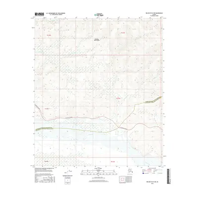
2016 Map of Big Delta B-5 SW
USGS Topo · Published 2016About this map
The Tanana River dominates the southern reaches of this landscape, its braided channels and wetlands forming a complex drainage system across the borough line. To the north, the terrain rises into the highlands of Harding- Birch Lakes, where a network of tributary streams including Shamrock Cr, Democrat Cr, and Junction Cr carve through the interior. This 2016 survey illustrates the intersection of natural waterways and modern infrastructure, with the Richardson Highway serving as the primary corridor cutting across the center of the sheet. The map also records the jurisdictional boundary between the Fairbanks North Star Borough Southeast Fairbanks Census Area, tracing how these administrative lines follow the contours of the Banner Cr watershed and the broad river valley below.
Find a feature on this map
16 named features on this map. Tap any name to fly to it.
Don’t see what you’re looking for? This feature index may not catch every label — zoom into the map to look around manually.
Map Details
Editions of this 2016 Big Delta B-5 SW Map
This is the sole edition of this map. No revisions or reprints were ever made.
Other maps of this area

1949 · Big Delta B-5
USGS Topo · 1:63,360

1949 · Big Delta B-6
USGS Topo · 1:63,360

1949 · Big Delta A-6
USGS Topo · 1:63,360

1950 · Big Delta
USGS Topo · 1:250,000

1950 · Big Delta A-5
USGS Topo · 1:63,360

1951 · Big Delta
USGS Topo · 1:250,000
1951 · Big Delta A-6
USGS Topo · 1:63,360

1952 · Big Delta A-5
USGS Topo · 1:63,360

1952 · Big Delta B-6
USGS Topo · 1:63,360

1952 · Big Delta B-5
USGS Topo · 1:63,360