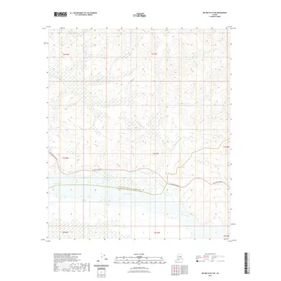
2021 Map of Big Delta B-5 SW
USGS Topo · Published 2021About this map
The Tanana River dominates the southern landscape of this Interior Alaska region, serving as the primary geographical anchor for a network of northern tributaries. The waterway forms a natural boundary between the Fairbanks North Star Borough and the Southeast Fairbanks Census Area. Cutting across the central terrain, the Richardson Highway provides the essential overland link, following the contours of the land just north of the river. This alignment illustrates the classic corridor development of the Alaskan Interior, where modern transportation infrastructure mirrors the ancient paths carved by water. Numerous seasonal and perennial streams like Banner Creek and Junction Cr drain the uplands, highlighting a complex hydrological system that defines the local topography and historical access routes into the surrounding wilderness.
Find a feature on this map
11 named features on this map. Tap any name to fly to it.
Don’t see what you’re looking for? This feature index may not catch every label — zoom into the map to look around manually.
Map Details
Editions of this 2021 Big Delta B-5 SW Map
This is the sole edition of this map. No revisions or reprints were ever made.
Other maps of this area

1949 · Big Delta B-5
USGS Topo · 1:63,360

1949 · Big Delta B-6
USGS Topo · 1:63,360

1949 · Big Delta A-6
USGS Topo · 1:63,360

1950 · Big Delta
USGS Topo · 1:250,000

1950 · Big Delta A-5
USGS Topo · 1:63,360

1951 · Big Delta
USGS Topo · 1:250,000
1951 · Big Delta A-6
USGS Topo · 1:63,360

1952 · Big Delta A-5
USGS Topo · 1:63,360

1952 · Big Delta B-6
USGS Topo · 1:63,360

1952 · Big Delta B-5
USGS Topo · 1:63,360