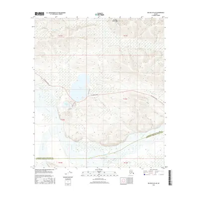
2016 Map of Big Delta B-6 SE
USGS Topo · Published 2016About this map
Birch Lake sits as a central landmark in this interior Alaskan landscape, marking a significant recreational and transport corridor southeast of Fairbanks. The region is defined by the Tanana River, which sweeps across the southwestern portion of the sheet, joined by the Little Delta River. This 2016 survey illustrates the vital role of the Richardson Highway in connecting these remote water bodies to the rest of the state.
Find a feature on this map
12 named features on this map. Tap any name to fly to it.
Don’t see what you’re looking for? This feature index may not catch every label — zoom into the map to look around manually.
Map Details
Editions of this 2016 Big Delta B-6 SE Map
This is the sole edition of this map. No revisions or reprints were ever made.
Other maps of this area

1949 · Big Delta B-5
USGS Topo · 1:63,360

1949 · Big Delta B-6
USGS Topo · 1:63,360

1949 · Big Delta A-6
USGS Topo · 1:63,360

1950 · Big Delta
USGS Topo · 1:250,000

1950 · Big Delta A-5
USGS Topo · 1:63,360

1951 · Big Delta
USGS Topo · 1:250,000
1951 · Big Delta A-6
USGS Topo · 1:63,360

1952 · Big Delta A-5
USGS Topo · 1:63,360

1952 · Big Delta B-6
USGS Topo · 1:63,360

1952 · Big Delta B-5
USGS Topo · 1:63,360