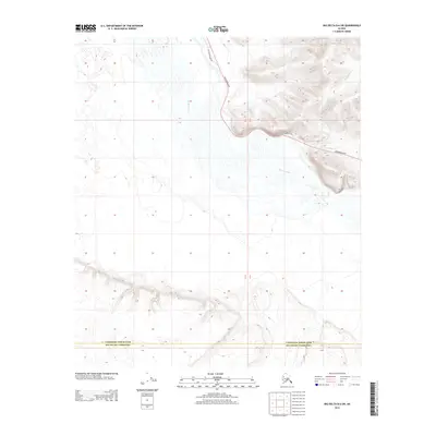
2013 Map of Big Delta B-6 SW
USGS Topo · Published 2013About this map
The Tanana River dominates this interior Alaska landscape, weaving through a complex network of channels and braided sandbars. Its vast floodplain is contrasted by the rising elevations along the eastern edge of the quadrangle, where Mosquito Cr cuts through the high ground. This 2013 survey illustrates the modern transportation corridor where the Richardson Hwy follows the terrain, accompanied by segments of the Old Richardson Hwy. These routes trace the historical path between the coast and the interior, serving as the primary artery for the region. The map also delineates the administrative boundary between Fairbanks North Star and Southeast Fairbanks, marking a transition between these two borough and census areas.
Find a feature on this map
5 named features on this map. Tap any name to fly to it.
Don’t see what you’re looking for? This feature index may not catch every label — zoom into the map to look around manually.
Map Details
Editions of this 2013 Big Delta B-6 SW Map
This is the sole edition of this map. No revisions or reprints were ever made.
Other maps of this area

1949 · Big Delta B-6
USGS Topo · 1:63,360

1949 · Big Delta A-6
USGS Topo · 1:63,360

1949 · Fairbanks A-1
USGS Topo · 1:63,360

1950 · Fairbanks
USGS Topo · 1:250,000

1950 · Big Delta
USGS Topo · 1:250,000

1950 · Fairbanks B-1
USGS Topo · 1:63,360

1951 · Big Delta
USGS Topo · 1:250,000
1951 · Fairbanks B-1
USGS Topo · 1:63,360
1951 · Big Delta A-6
USGS Topo · 1:63,360

1951 · Fairbanks
USGS Topo · 1:250,000