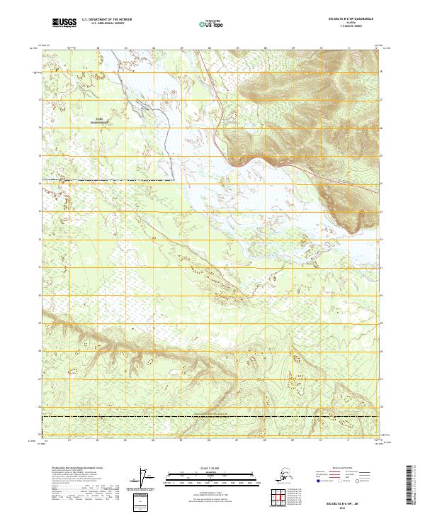
2021 Map of Big Delta B-6 SW
USGS Topo · Published 2021About this map
The Tanana River dominates this interior landscape, weaving through a complex network of wetlands and braided channels as it flows west. Along its northern banks, the Richardson Highway serves as the primary corridor for movement, connecting small residential spurs like Silver Lake Drive and Loon Song Lane to the broader Alaskan interior. The terrain transitions from the low-lying river basin to the higher elevations of the surrounding hills, such as those near Mosquito Cr in the northeast.
Find a feature on this map
13 named features on this map. Tap any name to fly to it.
Don’t see what you’re looking for? This feature index may not catch every label — zoom into the map to look around manually.
Map Details
Editions of this 2021 Big Delta B-6 SW Map
This is the sole edition of this map. No revisions or reprints were ever made.
Other maps of this area

1949 · Big Delta B-6
USGS Topo · 1:63,360

1949 · Big Delta A-6
USGS Topo · 1:63,360

1949 · Fairbanks A-1
USGS Topo · 1:63,360

1950 · Fairbanks
USGS Topo · 1:250,000

1950 · Big Delta
USGS Topo · 1:250,000

1950 · Fairbanks B-1
USGS Topo · 1:63,360

1951 · Big Delta
USGS Topo · 1:250,000
1951 · Fairbanks B-1
USGS Topo · 1:63,360
1951 · Big Delta A-6
USGS Topo · 1:63,360

1951 · Fairbanks
USGS Topo · 1:250,000