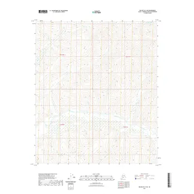
2021 Map of Big Delta C-4 NE
USGS Topo · Published 2021About this map
The Salcha River basin dominates this interior landscape within the Fairbanks North Star Borough, where the river's meandering course creates a broad, sediment-filled valley floor. This 2021 survey reveals a complex hydrological network defined by steep-walled tributaries like Caribou Cr and the curiously named No Grub Cr. The terrain is characterized by high, rhythmic contour lines that indicate significant elevation changes between the river basin and the surrounding uplands. Other prominent drainages including Bullfrog Cr, Pasco Cr, and Butte Cr feed into the primary river system, illustrating the natural drainage patterns of this Alaskan wilderness. In the northern reaches, Bonanza Cr cuts through the high ground, reflecting the typical landscape architecture of the region where water systems are the primary force shaping the topography.
Find a feature on this map
11 named features on this map. Tap any name to fly to it.
Don’t see what you’re looking for? This feature index may not catch every label — zoom into the map to look around manually.
Map Details
Editions of this 2021 Big Delta C-4 NE Map
This is the sole edition of this map. No revisions or reprints were ever made.
Other maps of this area

1950 · Big Delta
USGS Topo · 1:250,000

1951 · Big Delta
USGS Topo · 1:250,000

1958 · Big Delta C-4
USGS Topo · 1:63,360

1958 · Big Delta D-4
USGS Topo · 1:63,360

1958 · Big Delta C-3
USGS Topo · 1:63,360

1958 · Big Delta D-3
USGS Topo · 1:63,360

1958 · Big Delta
USGS Topo · 1:250,000
1973 · Big Delta D-3
USGS Topo · 1:63,360
2016 · Big Delta D-4 SE
USGS Topo · 1:25,000
2016 · Big Delta D-3 SW
USGS Topo · 1:25,000