
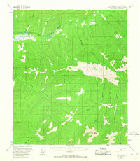
1958 Map of Big Delta D-4
USGS Topo · Published 1963About this map
The Chena River system dominates this Alaskan landscape, with the East Fork Chena River and S Fork Chena River carving through the high country. In this mid-century period, the area is defined by its drainage network rather than permanent settlements, featuring a series of creeks with names that hint at the region's prospecting history, such as Gold Creek, Little Gold Creek, and Bonanza Creek. A prominent high point known as The Butte rises in the southeastern section, providing a clear landmark amidst the complex topography.
Find a feature on this map
21 named features on this map. Tap any name to fly to it.
Don’t see what you’re looking for? This feature index may not catch every label — zoom into the map to look around manually.
Map Details
Editions of this 1958 Big Delta D-4 Map
2 editions found
Other maps of this area

1950 · Big Delta
USGS Topo · 1:250,000

1951 · Big Delta
USGS Topo · 1:250,000

1951 · Circle
USGS Topo · 1:250,000

1951 · Circle A-5
USGS Topo · 1:63,360

1952 · Circle A-4
USGS Topo · 1:63,360

1952 · Circle A-5
USGS Topo · 1:63,360

1954 · Circle A-5
USGS Topo · 1:63,360

1955 · Circle A-3
USGS Topo · 1:63,360

1955 · Circle
USGS Topo · 1:250,000

1958 · Big Delta C-5
USGS Topo · 1:63,360