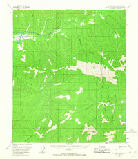
1958 Map of Big Delta D-4
USGS Topo · Published 1967About this map
The East Fork Chena River and S Fork Chena River define this remote interior landscape during the late 1950s. The region is largely uninhabited, save for a lone Cabin situated north of the river and a network of seasonal routes including a Winter Trail and several unmarked trails. This topography reveals the high-altitude terrain of the Fairbanks North Star Borough, dominated by a central ridge system that includes The Butte. The drainage patterns are intricate, with numerous creeks such as Gold Creek, Bonanza Creek, and Quartz Creek carving through the uplands. These names suggest the area's prospecting history and the search for minerals along the alluvial basins. The map also captures the official Base Line, marking an important surveying boundary in the Alaskan wilderness before more extensive development reached these high latitudes.
Find a feature on this map
23 named features on this map. Tap any name to fly to it.
Don’t see what you’re looking for? This feature index may not catch every label — zoom into the map to look around manually.
Map Details
Editions of this 1958 Big Delta D-4 Map
2 editions found

Other maps of this area

1950 · Big Delta
USGS Topo · 1:250,000

1951 · Big Delta
USGS Topo · 1:250,000

1951 · Circle
USGS Topo · 1:250,000

1951 · Circle A-5
USGS Topo · 1:63,360

1952 · Circle A-4
USGS Topo · 1:63,360

1952 · Circle A-5
USGS Topo · 1:63,360

1954 · Circle A-5
USGS Topo · 1:63,360

1955 · Circle A-3
USGS Topo · 1:63,360

1955 · Circle
USGS Topo · 1:250,000

1958 · Big Delta C-5
USGS Topo · 1:63,360