
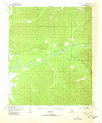
1950 Map of Big Delta D-6
USGS Topo · Published 1961About this map
The Chena River and its massive South Fork Chena River dominate this interior Alaskan landscape during the mid-twentieth century. This remote territory, documented just as modern infrastructure began to push inland, shows a transitional stage of development with segments of Road marked as Under Construction alongside established routes like the Winter Trail. The presence of several isolated cabins and a primitive Airstrip near Flat Creek suggests a reliance on bush aviation and seasonal travel. Notable geological and hydrothermal features include the Hot Springs near Hodgins Slough and a recorded Pingo to the southeast, highlighting the unique periglacial landforms of the region. Drainage patterns are intricately detailed through numerous tributaries such as Caribou Creek, Anaconda Creek, and Hunts Creek.
Find a feature on this map
21 named features on this map. Tap any name to fly to it.
Don’t see what you’re looking for? This feature index may not catch every label — zoom into the map to look around manually.
Map Details
Editions of this 1950 Big Delta D-6 Map
2 editions found
Other maps of this area

1945 · Livengood
USGS Topo · 1:250,000

1949 · Fairbanks D-1
USGS Topo · 1:62,500

1949 · Fairbanks C-1
USGS Topo · 1:63,360

1949 · Big Delta C-6
USGS Topo · 1:63,360

1950 · Fairbanks
USGS Topo · 1:250,000

1950 · Big Delta
USGS Topo · 1:250,000

1950 · Fairbanks C-1
USGS Topo · 1:63,360

1951 · Big Delta
USGS Topo · 1:250,000

1951 · Fairbanks
USGS Topo · 1:250,000

1951 · Livengood
USGS Topo · 1:250,000