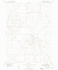
1948 Map of Big Foot Butte
USGS Topo · Published 1948About this map
Big Foot Butte dominates the western portion of this high desert landscape along the border of Idaho and Ada County. Surveyed in the late 1940s, this area is characterized by drainage patterns and isolated water sources that were vital to the livestock and transport history of the Snake River Plain. The map details the seasonal hydrology of the region, specifically Tadpole Lake and the Wind Butte Lakes to the northeast. Tracing the path of Rabbit Creek as it winds through the eastern sections reveals the natural corridors used for movement across the volcanic plateau. While the area lacks dense settlements, the presence of these named water features and the massive profile of the butte provide essential landmarks for understanding the early grazing and surveying history of southern Idaho.
Find a feature on this map
5 named features on this map. Tap any name to fly to it.
Don’t see what you’re looking for? This feature index may not catch every label — zoom into the map to look around manually.
Map Details
Editions of this 1948 Big Foot Butte Map
4 editions found
Other maps of this area

1892 · Bisuka
USGS Topo · 1:125,000

1894 · Bisuka
USGS Topo · 1:125,000

1947 · Jackass Butte
USGS Topo · 1:24,000

1947 · Wild Horse Butte
USGS Topo · 1:24,000

1947 · Dorsey Butte
USGS Topo · 1:24,000

1948 · Castle Butte
USGS Topo · 1:24,000

1948 · Big Foot Butte
USGS Topo · 1:24,000

1948 · Wild Horse Butte
USGS Topo · 1:24,000

1948 · Jackass Butte
USGS Topo · 1:24,000

1948 · Dorsey Butte
USGS Topo · 1:24,000