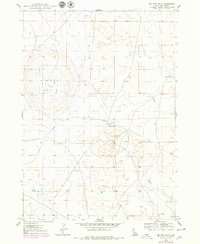
1948 Map of Big Foot Butte
USGS Topo · Published 1979About this map
Big Foot Butte rises above the arid landscape of southern Ada County, serving as the primary landmark in this survey of high desert terrain. The topography, mapped in 1947 and updated with aerial observations from the 1970s, reveals a network of seasonal water sources and drainages essential to life in this volcanic region. Small basins like Tadpole Lake and Wind Butte Lakes offer rare catchments for moisture, while Rabbit Creek carves a path through the southern half of the quadrangle. The map captures a moment when traditional ground surveying met modern photogrammetry, evidenced by the purple revisions that document shifts in the subtle desert tracks and fences that crisscross the sagebrush flats between the buttes.
Find a feature on this map
6 named features on this map. Tap any name to fly to it.
Don’t see what you’re looking for? This feature index may not catch every label — zoom into the map to look around manually.
Map Details
Editions of this 1948 Big Foot Butte Map
4 editions found
Other maps of this area

1892 · Bisuka
USGS Topo · 1:125,000

1894 · Bisuka
USGS Topo · 1:125,000

1947 · Jackass Butte
USGS Topo · 1:24,000

1947 · Wild Horse Butte
USGS Topo · 1:24,000

1947 · Dorsey Butte
USGS Topo · 1:24,000

1948 · Castle Butte
USGS Topo · 1:24,000

1948 · Big Foot Butte
USGS Topo · 1:24,000

1948 · Wild Horse Butte
USGS Topo · 1:24,000

1948 · Jackass Butte
USGS Topo · 1:24,000

1948 · Dorsey Butte
USGS Topo · 1:24,000