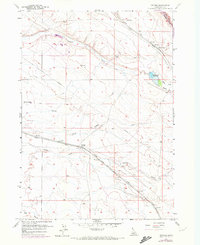
1957 Map of Owyhee
USGS Topo · Published 1972About this map
The Union Pacific (Oregon Short Line) cuts a straight path through this high desert corridor of Ada County, anchoring the small rail stop of Owyhee amidst a landscape defined by water management and transit. In the late 1950s, the terrain was shaped by an intricate network of irrigation including the Ditch and Pipeline systems that fed several Reservoirs, vital for life in the arid plains southeast of Boise. To the west, the settlement of Pleasant Valley sits near the head of these drainage systems. The map documents early aviation and rail infrastructure with the presence of a Landing Field near Sand Creek and a Water Tank along the tracks at Owyhee. Natural features like Fivemile Canyon, Tenmile Creek, and Blacks Creek Reservoir break the open ground, showing how the mid-century infrastructure followed the natural contours of the Indian Creek drainage basin.
Find a feature on this map
19 named features on this map. Tap any name to fly to it.
Don’t see what you’re looking for? This feature index may not catch every label — zoom into the map to look around manually.
Map Details
Editions of this 1957 Owyhee Map
3 editions found
Other maps of this area

1892 · Boise
USGS Topo · 1:125,000

1892 · Bisuka
USGS Topo · 1:125,000

1894 · Bisuka
USGS Topo · 1:125,000

1897 · Boise
USGS Topo · 1:125,000

1953 · Cloverdale
USGS Topo · 1:24,000

1954 · Boise South
USGS Topo · 1:24,000

1954 · Boise
USGS Topo · 1:62,500

1955 · Christmas Mtn
USGS Topo · 1:24,000
1955 · Coyote Butte
USGS Topo · 1:24,000

1955 · Orchard
USGS Topo · 1:24,000