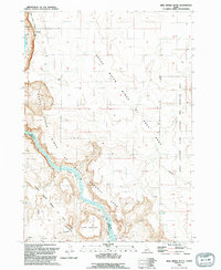
1992 Map of Wild Horse Butte
USGS Topo · Published 1992About this map
The Snake River carves a deep path through the canyon lands of Ada and Owyhee Counties, defining the landscape of the Snake River Birds Of Prey Natural Area in the early 1990s. This survey captures a rugged stretch of the river where historical transportation routes intersect with modern conservation and military use. Traces of pioneer history are preserved in the south, where the Oregon Trail (South Alternate) skirts the canyon rim near Wild Horse Butte. Further north, Swan Falls marks a focal point for activity, including an Old Ferry Site and a nearby Radio Facility. The map reveals the intricate topography of the canyon floor, identifying river features like Thomas Flats and Big Foot Bar, alongside small-scale industrial attempts such as a Prospect. To the east, the terrain levels out into the Idaho National Guard Training Area, highlighting the varied jurisdictional uses of this Idaho high desert.
Find a feature on this map
20 named features on this map. Tap any name to fly to it.
Don’t see what you’re looking for? This feature index may not catch every label — zoom into the map to look around manually.
Map Details
Editions of this 1992 Wild Horse Butte Map
This is the sole edition of this map. No revisions or reprints were ever made.
Other maps of this area

1892 · Bisuka
USGS Topo · 1:125,000

1894 · Bisuka
USGS Topo · 1:125,000

1947 · Jackass Butte
USGS Topo · 1:24,000

1947 · Wild Horse Butte
USGS Topo · 1:24,000

1948 · Castle Butte
USGS Topo · 1:24,000

1948 · Big Foot Butte
USGS Topo · 1:24,000

1948 · Wild Horse Butte
USGS Topo · 1:24,000

1948 · Jackass Butte
USGS Topo · 1:24,000

1948 · Big Foot Butte
USGS Topo · 1:62,500

1948 · Sinker Butte
USGS Topo · 1:24,000