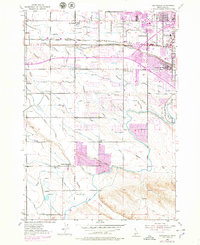
1953 Map of Cloverdale
USGS Topo · Published 1979About this map
Hydraulic engineering and mid-century suburban expansion define this study of the Boise Valley. The landscape is dominated by a complex network of irrigation infrastructure, where the massive New York Canal and Ridenbaugh Canal feed a secondary system of laterals, including the Boller Lateral and Folsom Lateral. These waterways supported the transition from agricultural tracts to the residential developments seen near Boise Junction and the West Boise Jr High Sch.
Find a feature on this map
57 named features on this map. Tap any name to fly to it.
Don’t see what you’re looking for? This feature index may not catch every label — zoom into the map to look around manually.
Map Details
Editions of this 1953 Cloverdale Map
4 editions found
Other maps of this area

1892 · Boise
USGS Topo · 1:125,000

1892 · Bisuka
USGS Topo · 1:125,000

1894 · Bisuka
USGS Topo · 1:125,000

1897 · Boise
USGS Topo · 1:125,000

1953 · Eagle
USGS Topo · 1:24,000

1953 · Cloverdale
USGS Topo · 1:24,000

1953 · Meridian
USGS Topo · 1:24,000

1953 · Star
USGS Topo · 1:24,000

1954 · Boise South
USGS Topo · 1:24,000

1954 · Boise North
USGS Topo · 1:24,000