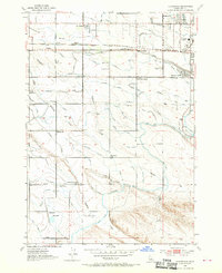
1953 Map of Cloverdale
USGS Topo · Published 1970About this map
New York Canal and the Ridenbaugh Canal dominate the landscape west of Boise, illustrating the complex irrigation network that transformed the high desert of Ada County. This 1950s survey shows a rural environment transitioning toward suburban expansion, with small rail stops like Beatty and Perkins along the Union Pacific Railroad. Local education and community life are anchored by numerous neighborhood schools, including Cole School, McKinley School, and the noted Maple Grove School (Aband). South of the main settlements, the Tenmile Rodeo Grounds and Hubbard Reservoir provide focal points for recreation and water management. The presence of multiple broadcast facilities, such as the KDSN Radio Towers and KGEM Radio Tower, signals the area's growing importance as a regional communication hub during the mid-century era.
Find a feature on this map
68 named features on this map. Tap any name to fly to it.
Don’t see what you’re looking for? This feature index may not catch every label — zoom into the map to look around manually.
Map Details
Editions of this 1953 Cloverdale Map
4 editions found
Other maps of this area

1892 · Boise
USGS Topo · 1:125,000

1892 · Bisuka
USGS Topo · 1:125,000

1894 · Bisuka
USGS Topo · 1:125,000

1897 · Boise
USGS Topo · 1:125,000

1953 · Eagle
USGS Topo · 1:24,000

1953 · Cloverdale
USGS Topo · 1:24,000

1953 · Meridian
USGS Topo · 1:24,000

1953 · Star
USGS Topo · 1:24,000

1954 · Boise South
USGS Topo · 1:24,000

1954 · Boise North
USGS Topo · 1:24,000