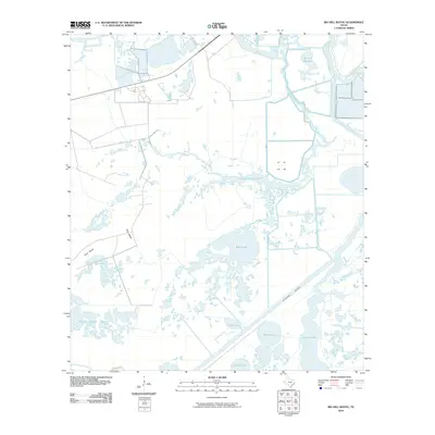
2010 Map of Big Hill Bayou
USGS Topo · Published 2010About this map
The Intracoastal Waterway cuts a straight path through the low-lying coastal marshes of Jefferson County, defining the industrial and maritime character of this landscape near Port Arthur. This 2010 survey illustrates a complex hydrologic network where the Big Hill Reservoir and the Taylor Bayou Outfall Canal interface with natural features like Taylor Bayou and Big Hill Bayou. The terrain is characterized by slightly elevated rises known as islands, including Hog Island and Gum Island, which stand out amidst the extensive Willow Slough Marsh. Numerous water bodies such as Shallow Prong Lake, Blind Lake, and Barnett Lake dot the wetlands, reflecting the intricate drainage patterns of the Texas Gulf Coast. Aside from the ironically named Need More Rd, the area remains largely defined by its water management systems and natural bayous.
Find a feature on this map
15 named features on this map. Tap any name to fly to it.
Don’t see what you’re looking for? This feature index may not catch every label — zoom into the map to look around manually.
Map Details
Editions of this 2010 Big Hill Bayou Map
This is the sole edition of this map. No revisions or reprints were ever made.
Other maps of this area

1943 · Port Arthur North
USGS Topo · 1:24,000

1943 · Port Arthur South
USGS Topo · 1:24,000

1943 · Fannett East
USGS Topo · 1:24,000

1944 · Sabine Pass
USGS Topo · 1:31,680

1945 · Fannett East
USGS Topo · 1:31,680

1950 · Houston
USGS Topo · 1:250,000

1954 · Port Arthur
USGS Topo · 1:250,000

1956 · Houston
USGS Topo · 1:250,000
1956 · Port Arthur
USGS Topo · 1:250,000
1957 · Sabine Pass
USGS Topo · 1:62,500