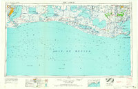
1956 Map of Port Arthur
USGS Topo · Published 1965About this map
Port Arthur and its surrounding coastal marshlands are depicted here during a period of mid-century industrial and maritime expansion. The map illustrates the complex water systems of the Chenier Plain, where the Intracoastal Waterway links the major basins of Sabine Lake, Calcasieu Lake, and White Lake. The landscape is defined by its ridges or cheniers, such as Grand Cheniere Ridge and Pumpkin Ridge, which provide the only high ground for settlements like Grand Cheniere and Pecan Island.
Find a feature on this map
111 named features on this map. Tap any name to fly to it.
Don’t see what you’re looking for? This feature index may not catch every label — zoom into the map to look around manually.
Map Details
Editions of this 1956 Port Arthur Map
3 editions found
Other maps of this area

1926 · Terry
USGS Topo · 1:24,000

1926 · Vidor
USGS Topo · 1:24,000

1932 · Abbeville SW
USGS Topo · 1:31,680

1932 · Sabine Pass NE
USGS Topo · 1:31,680

1932 · Constance Bayou NE
USGS Topo · 1:31,680

1932 · Abbeville SE
USGS Topo · 1:31,680

1932 · Moss Lake
USGS Topo · 1:31,680

1932 · Abbeville NE
USGS Topo · 1:31,680

1932 · Beaumont
USGS Topo · 1:62,500

1932 · Pecan Island SE
USGS Topo · 1:31,680