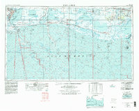
1956 Map of Port Arthur
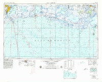
USGS Topo · Published 1979About this map
Port Arthur and its neighboring industrial centers of Nederland and Port Neches anchor the western edge of this coastal survey, where the Neches River meets Sabine Lake. The landscape transition from the refineries and Southern Pacific rail lines of Jefferson County into the expansive wetlands of Cameron Parish is meticulously documented. The map details a complex hydraulic environment of drainage and navigation, featuring the Intracoastal Waterway and various arteries like Starks Canal and Willow Bayou Canal. Inland from the Gulf of Mexico, the terrain is defined by isolated settlements and extensive wildlife habitats, including the Sabine National Wildlife Refuge and Lacassine National Wildlife Refuge. The eastern reaches toward Abbeville and Kaplan reveal a pattern of coastal ridges such as Hackberry Ridge and Little Chenier Ridge, which have historically provided higher ground for communities like Grand Chenier and Pecan Island.
Find a feature on this map
115 named features on this map. Tap any name to fly to it.
Don’t see what you’re looking for? This feature index may not catch every label — zoom into the map to look around manually.
Map Details
Editions of this 1956 Port Arthur Map
3 editions found

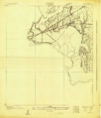
Other maps of this area

1926 · Terry
USGS Topo · 1:24,000
1926 · Vidor
USGS Topo · 1:24,000

1932 · Abbeville SW
USGS Topo · 1:31,680

1932 · Sabine Pass NE
USGS Topo · 1:31,680

1932 · Constance Bayou NE
USGS Topo · 1:31,680

1932 · Abbeville SE
USGS Topo · 1:31,680

1932 · Moss Lake
USGS Topo · 1:31,680

1932 · Abbeville NE
USGS Topo · 1:31,680

1932 · Beaumont
USGS Topo · 1:62,500

1932 · Pecan Island SE
USGS Topo · 1:31,680