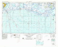
1956 Map of Port Arthur
USGS Topo · Published 1979About this map
The industrial hub of Port Arthur and the expansive wetlands of the Louisiana coast anchor this regional overview. The landscape is defined by its complex hydrology, where the Sabine River and Sabine Lake meet the Gulf of Mexico. This map illustrates the vital maritime infrastructure of the era, including the Intracoastal Waterway and the Sabine-Neches Waterway, which supported the region's shipping and petrochemical interests.
Find a feature on this map
66 named features on this map. Tap any name to fly to it.
Don’t see what you’re looking for? This feature index may not catch every label — zoom into the map to look around manually.
Map Details
Editions of this 1956 Port Arthur Map
3 editions found
Other maps of this area

1926 · Terry
USGS Topo · 1:24,000

1926 · Vidor
USGS Topo · 1:24,000

1932 · Abbeville SW
USGS Topo · 1:31,680

1932 · Sabine Pass NE
USGS Topo · 1:31,680

1932 · Constance Bayou NE
USGS Topo · 1:31,680

1932 · Abbeville SE
USGS Topo · 1:31,680

1932 · Moss Lake
USGS Topo · 1:31,680

1932 · Abbeville NE
USGS Topo · 1:31,680

1932 · Beaumont
USGS Topo · 1:62,500

1932 · Pecan Island SE
USGS Topo · 1:31,680