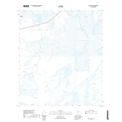
2019 Map of Big Hill Bayou
USGS Topo · Published 2019About this map
Taylor Landing sits at the edge of a complex coastal landscape defined by the intersection of natural wetlands and industrial waterway engineering. This Jefferson County terrain is characterized by the expansive Willow Slough Marsh and a network of tidal channels, including the Taylor Bayou Outfall Canal and the massive Intracoastal Waterway. The presence of the Big Hill Reservoir and numerous internal bodies of water like Shallow Prong Lake and Barnett Lake indicates a region heavily managed for water control and industrial transit. Topographical high points such as Hog Island and Gum Island provide contrast to the low-lying bayous and sloughs. This map illustrates the modern infrastructure of the Texas Gulf Coast, where human-made canals and reservoirs are intricately woven into the existing estuarine system of Big Hill Bayou and Taylor Bayou.
Find a feature on this map
21 named features on this map. Tap any name to fly to it.
Don’t see what you’re looking for? This feature index may not catch every label — zoom into the map to look around manually.
Map Details
Editions of this 2019 Big Hill Bayou Map
This is the sole edition of this map. No revisions or reprints were ever made.
Other maps of this area

1943 · Port Arthur North
USGS Topo · 1:24,000

1943 · Port Arthur South
USGS Topo · 1:24,000

1943 · Fannett East
USGS Topo · 1:24,000

1944 · Sabine Pass
USGS Topo · 1:31,680

1945 · Fannett East
USGS Topo · 1:31,680

1950 · Houston
USGS Topo · 1:250,000

1954 · Port Arthur
USGS Topo · 1:250,000

1956 · Houston
USGS Topo · 1:250,000
1956 · Port Arthur
USGS Topo · 1:250,000
1957 · Sabine Pass
USGS Topo · 1:62,500