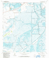
1993 Map of Big Hill Bayou
USGS Topo · Published 1994About this map
Big Hill Oil Field dominates the western landscape of this coastal Jefferson County survey, where industrial extraction meets expansive wetlands. The infrastructure of the oil field, including numerous Oil Wells and a network of pipelines, sits adjacent to the sprawling McFaddin National Wildlife Refuge and J. D. Murphree Wildlife Management Area. This 1993 edition captures the complex hydraulic management of the Texas coast, featuring the Intracoastal Waterway, Magnolia Cut, and the Outfall Canal.
Find a feature on this map
36 named features on this map. Tap any name to fly to it.
Don’t see what you’re looking for? This feature index may not catch every label — zoom into the map to look around manually.
Map Details
Editions of this 1993 Big Hill Bayou Map
This is the sole edition of this map. No revisions or reprints were ever made.
Other maps of this area

1943 · Port Arthur North
USGS Topo · 1:24,000

1943 · Port Arthur South
USGS Topo · 1:24,000

1943 · Fannett East
USGS Topo · 1:24,000

1944 · Sabine Pass
USGS Topo · 1:31,680

1945 · Fannett East
USGS Topo · 1:31,680

1950 · Houston
USGS Topo · 1:250,000

1954 · Port Arthur
USGS Topo · 1:250,000

1956 · Houston
USGS Topo · 1:250,000
1956 · Port Arthur
USGS Topo · 1:250,000
1957 · Sabine Pass
USGS Topo · 1:62,500